Hiking tours are perfect for starting your holiday week, in between or as preparation for longer hiking tours in the mountains. Start your hike straight from your accommodation provider or make use of one of the three mountain railways – Hochzeiger Bergbahnen, Rifflsee Bergbahnen or Pitztal Glacier – to spare your legs and energy reserves on the way up.
to shopping cart
to cart for brochures
Hiking tours

Hiking tours in Pitztal
Walking in Pitztal’ s mountains
Regions:
Whole Pitztal
Hochzeiger
Gletscher
Rifflsee
Hiking tours in Pitztal
Pitztal offers a diverse range of hikes – from forest hikes to hikes through gorges and romantic vie ferrates with breath-taking panoramic views. Start your hiking week with a hiking tour before venturing out to a breath-taking summit. Hiking tours in Pitztal are perfectly suited as preparation and fitness training for longer hiking tours.
Top hiking tours in our villages…
Arzl: Luis-Trenker trail, Adlerhorst
Wenns: Large Harbe pond circular route, Hike to Kielebergalm
Jerzens: Stuibenwasserfall [waterfall], Sechszeiger
St Leonhard: Almenweg [catered mountain hut tour], Rüsselsheimer Hütte
Sitebuilder

Luis Trenker path

The viewing platfrom Adlerhorst

Stuiben waterfall in Jerzens Schön

Sechszeiger reservoir
Categories
Difficulty
Distance
Duration
Altitude
large village hike Jerzens
Ausgangspunkt
Car park Kirche Jerzens (1103m)
Endpunkt
Car park Kirche Jerzens (1103m)
Starting point of this demanding village hike is the car park by the church. Walk on past the mill (bread is baked and sold here weekly during the summer months) and walk upwards in several serpentines to the hamlet Egg. The secluded hamlet rewards your strenuous climb with a beautiful view of the valley basin with the villages Wenns and Piller. Take a shortcut from the access road following a steep path by turning off from the hamlet of Breitwies in direction of Haag. The beautifully landscaped path via Haag continues in the direction of Larchwies, then cross the Hochzeiger Road to continue walking on a track to the hamlet of Falsterwies. A somewhat steeper path leads up to the country road, which you have to follow for a short section. Once you get to a beautiful chapel, turn off into a farm track to the right. The track leads back to your starting point in the village centre of Jerzens.
Hike from Matzlewald to Jerzens fishpond
Ausgangspunkt
District of Matzlewald, Säge [sawmill] (1138m)
Endpunkt
District of Matzlewald, Säge [sawmill] (1135m)
Walk along the shaded forest road in the direction of Kienberg. When you come to a fork, take a left and follow a steep path to Kienberg. Once there, cross the road and turn left towards the Pitze river. Continue to walk by a flat and even path to the Jerzens fishpond. Return to Matzlewald by the same route.
Pitzenhöfe – Leins – retour
Ausgangspunkt
Fork before the football pitch (863m)
Endpunkt
Fork before the football pitch (862m)
Starting point before the football pitch. Turn right at the chapel, located directly adjacent to the road. Then, after about 200 m turn left in the direction of Unterleins. Once there, walk past the church to the bus stop and over a farm track to Oberleins. Return to the starting point via the same route.
Two lake tour
Ausgangspunkt
Rifflsee gondola bottom station (2291m)
Endpunkt
Rifflsee gondola valley station (1674m)
Take the Rifflsee gondola to the top station, then turn right and follow the signs to the Rifflseerundweg (circular
route) all the way to where it joins with a high-level trail, the Offenbacher Höhenweg. After approximately 1 hour walking time, turn off left on a waymark ed steep path to the Plodersee lake. Descend on a waymarked steep track, which joins up with the another high-level trail, the Fuldaer Höhenweg. From there, continue to walk in the
direction of the catered mountain hut Taschach Alm and keep on walking to return to the start in Mandarfen.
Mittagskogel summit tour starting from the top station gletsherexpress
Ausgangspunkt
top station of the Glacier Express (2847m)
Endpunkt
top station of the Glacier Express (2844m)
To the left of the top station of the Glacier Express [Gletscherexpress] trail over gravelly and rocky terrain leads you to the Mittagskogel peak (3,159 m). Please note that the trail is very steep so should not be attempted unless hikers are sure-footed. You will be rewarded with impressive vistas of the valley and surrounding glacier and Alps. Descend by the outward route and return to the top station of the Glacier Express.
Hike to Ritzenried
Ausgangspunkt
fire station Jerzens (1089m)
Endpunkt
fire station Jerzens (1100m)
Starting point: opposite the fire station, on the right hand side of the Mühlbach stream. The track begins with an easy ascent, with only a few minor hills to climb. At the first fork, follow the path to the right to the hamlet of Schön and continue to Ritztenried. Return via the same route.
Circular route Mittelberg with" Pitztaler Sagensteig"
Ausgangspunkt
valley station Rifflseebahn/Mandarfen (1675m)
Endpunkt
valley station Rifflseebahn/Mandarfen (1675m)
From the car park of Rifflsee gondola cross the bridge and turn left to walk on the wide agricultural road up to the catered mountain hut Taschach Alm. From there follow the road in the direction of Taschachhaus for a short stretch. Straight after the first bridge a path forks of to the left through the Mittelbergler forest to the valley station of the glacier express and from there on to Mittelberg. Since 2019, then follow the newly built “Pitztaler Sagensteig” [path of Pitztal’s legends]. Find out about the myths and legends of Pitztal at five stops along this path up to the catered mountain hut Gletscherstube at the foot of the Mittelberg glacier. You can return back to Mittelberg via the same path or follow the agricultural road or the Talwanderweg [valley hiking trail] to Mandarfen.
Hike to Pitzenschlucht [gorge]
Ausgangspunkt
Car park Kirche Jerzens (1105m)
Endpunkt
Car park Kirche Jerzens (1103m)
Starting point: Jerzens town centre. Follow the path in the direction of Niederhof, after crossing the Pitztal country road continue a little further on a tarmac road to Kienberg. Turn left at the first crossroads, follow the path, which will run into a steep track a to the Pitzenschlucht gorge. You can choose to either return by the same route or via the hamlet of Schön.
Circular route Leins - Wenns - Arzl-Ried
Ausgangspunkt
Church in Leins (1068m)
Endpunkt
Church in Leins (1060m)
Starting point: Car park by the church Leins. At the church square turn right to the Karrertrog until you reach a chapel. Once there, turn right in the direction of the Karrer Wiesen and follow a forest path to the hamlet of Pitzenhöfe. From there, you may choose to continue walking to Wenns or return to Leins. To return to the start, take the path on the right after the Pitzenhöfe chapel in the direction of the Klärwerk [waterprocessing unit]. When you reach a crossroads, turn right and walk on a forest path along the river Pitze to the Blonerstein and Arzl-Ried. Once there, a forest path takes you back to the starting point.
Hike to Hochaster Alm
Ausgangspunkt
Plattenrain (1474m)
Endpunkt
Plattenrain (1480m)
Walk on a steeper path from Plattenrain to the catered mountain hut Hochaster Alm. Initially return via the same route but continue to walk on the left after the fork. The forest road leads past Timler Alm (non-catered mountain hut) back to the starting point.
Region:
Hochzeiger
Hochzeiger hiking tours
Far-reaching views at Sechszeiger
Hochzeiger hiking resort offers a network of 100 kilometres of marked hiking trails spread over four alpine levels. Spare your legs and quickly get up to 2,370 metres at the top station of Sechzeiger double chair lift with the mountain railways at Hochzeiger ski resort. From there, you can start your planned hike in Pitztal.
Sitebuilder
A selection of hiking tours at Hochzeiger
| Hiking tips from the Sechszeiger lift top station | |
|---|---|
| (B) * |
To the Sechszeiger at 2,395 m and back to the "Landschaftsteich" lake before descending to the Kalbenalm. From there either continue along Path to the Tanzalm (Jerzner Alm) or walk direct to the gondola top station. |
| (C) * |
To the Sechszeiger and then descend in a northerly direction to the Leiner Alm (1 hour) before returning to the bottom lift station (1 hour 30 min.). |
| (D) * |
From the Sechszeiger descend in a northerly direction along through the Oberlang Valley to the Kalbenalm. From there either continue along to the Tanzalm (Jerzner Alm) or walk directly to the gondola top station. |
| Hiking tips from the Gondola top station | |
|---|---|
| (H) * |
To the Zollberg at 2,225 m from where you have a magnificent panorama view into the Inner Pitz Valley and across to the Wildspitze mountain. |
| (I) * |
To the Kalbenalm and return to the Tanzalm. |
| (J) * |
To the Jerzner Alm (5 min.) and continue to the Hochzeigerhaus (15 min.). Take either the "Bärensteig" or the "Außerwaldweg" to the bottom station. |
| (K) * |
To the valley station via the "Innerwald". Walking time: 1 hour. easy hike |
| (L) * |
To the valley station via the "Rodelweg". |
| (M) * |
Walk to the Kalbenalm (30 min.) and continue through the Oberlang Valley until you reach the path leading down from the Sechszeiger lift which takes you to the Leiner Alm (1 hour 15 min.). From the Leiner Alm to the bottom station (1 hour 30 min.). Walking time: 3 hours 15 min. intermediate hike |
* look up in the Hochzeiger hiking tips brochure

hiking at Sechszeiger peak in Pitztal

360 degree panorama at the sechszeiger peak

Swiss stone pine forest at Hochzeiger

Relaxing at Sechszeiger Peak, 2,370 m
Region:
Gletscher
Pitztal Glacier - Towards the Eternal Ice
Pitztal Glacier hiking tours
Although this is really high Alpine terrain, Pitztal Glacier offers a huge choice of marvelous Alpine walking tours between two and five hiking hours. Of course, sturdy mountain hiking boots, surefootedness and appropriate clothes (pullover, windbreaker, sun glasses, sunscreen) are an absolute must.
Important Information:
- All walking times listed below are roughly estimated times
- Always plan a tour in advance according to your personal fitness and skills
- Take a look at the local weather report and walk back in case of danger
- For more detailed information please contact the certified Pitztal Mountain Guides at any time
Sitebuilder
- Mittagskogel Walking Tour 3,159 m (View of the Alps & the Valley)
Walking time: 2 hours up to the peak
Difficulty level: red/black
- Braunschweiger Hütte Walking Tour
Walking time: 1,5 hours up to the mountain hut
Attention: glacier crossing!
- Braunschweiger Hütte incl. Pitztaler Jöchl 2,996 m
Walking time: 3 hours
Difficulty level: red
- Short hikes/walks at Pitztal Glacier
- Alpine hiking tours around Pitztal Glacier
- High Alpine peak tours starting at Pitzal Glacier
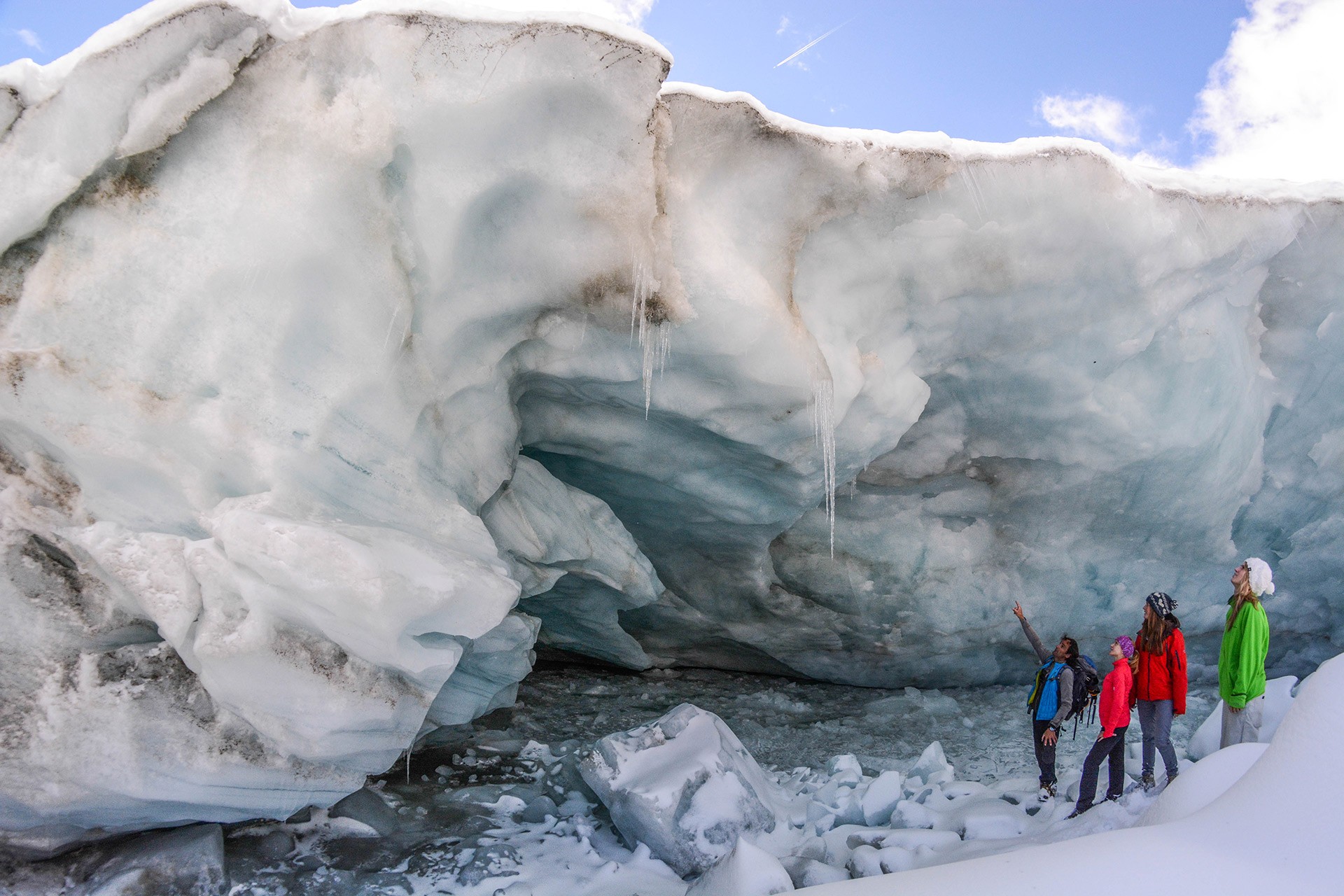
Refreshing Moments on a Guided Glacier Tour at Pitztal Glacier
Region:
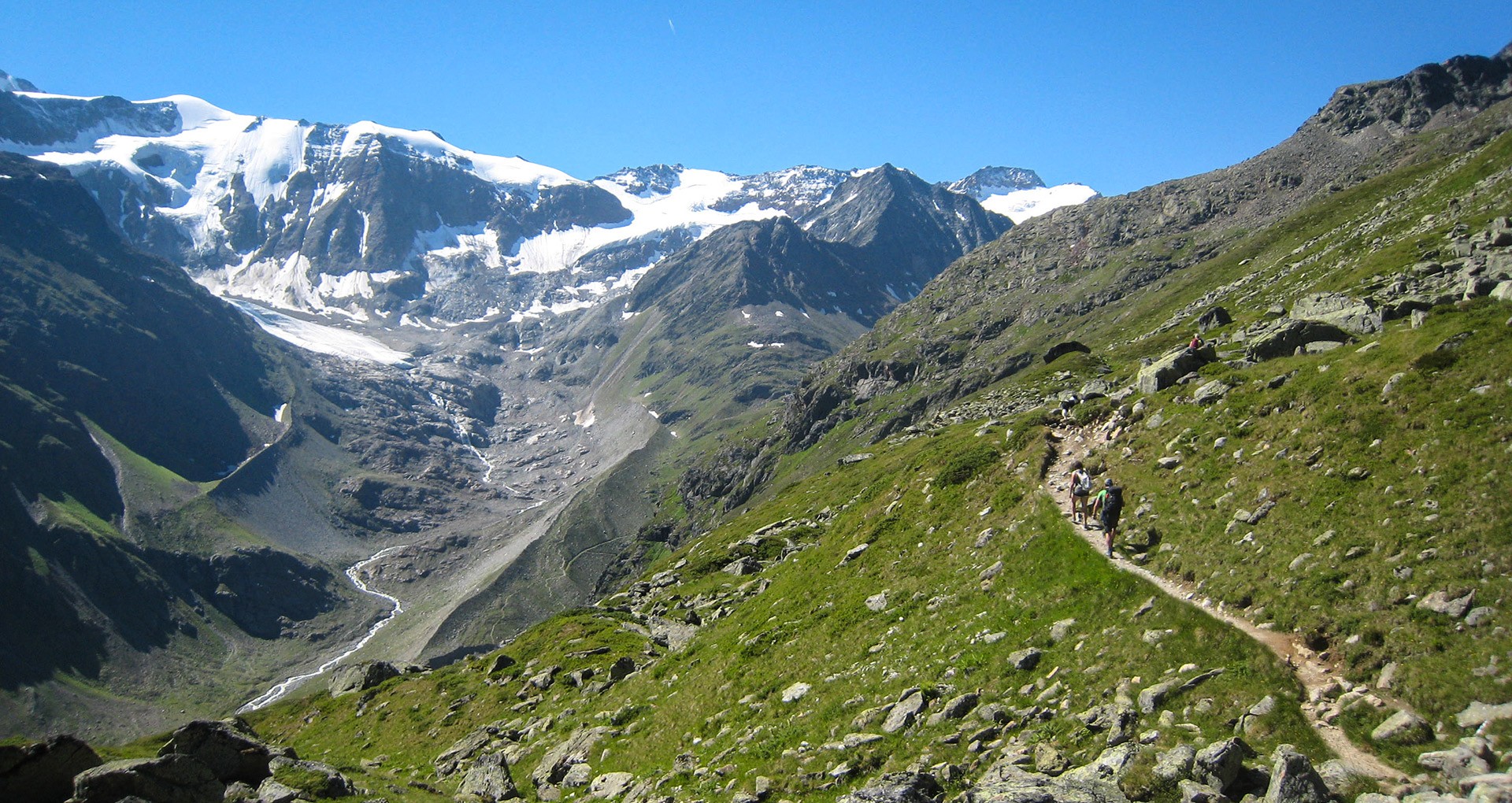
Rifflsee
Day Tours for Hikers
Varied Mountain Hikes in the Rifflsee Area
Thanks to top modern lift technologies, the Rifflsee mountain gondola takes you from Mandarfen up to 2,300 meters altitude within a few minutes.
Once on top, you can choose from a myriad of hiking trails and routes between two and five walking hours. Sturdy mountain hiking boots, surefootedness and appropriate clothes/mountain equipment (pullover, windbreaker, sun glasses, sunscreen) are an absolute must.
Important Information:
- All walking times listed below are roughly estimated times
- Always plan a tour in advance according to your personal fitness and skills
- Take a look at the local weather report and walk back in case of danger
- For more detailed information please contact the certified Pitztal Mountain Guides at any time
Sitebuilder
Rifflsee Hiking Paths and Trail Running Routes
Starting point: Rifflseebahn (gondola) top station - Restaurant Sunna Alm 2,291 m
- Plodersee Loop Tour: hiking trail to a crystal clear mountain lake at 2,380 m (you can even see the lake bottom!)
Walking time: approx. 4 hours
Difficulty level: red
- Wurmtal & Löcher Hike: walking tour to Rifflferner glacier (part of the "Offenbacher Höhenweg")
Walking time: approx. 2-4 hours (depending on stamina)
- Hirschtal Valley Hike: descent via Hirschtal to Tieflehn or Mandarfen, 600 meters of altitude difference
walking time, descent: approx. 1 hour
- Rifflsee Panorama Footpath: valley hike via Rifflseehütte or Muldennpiste slope
Walking time: approx. 1.5-2 hours
- Walking trail or cart trail to Taschach Alm cheese dairy (serviced)
Walking time: approx. 1.5-2 hours
Difficulty level: blue
- Fuldaer High Elevation Trail: panoramic hiking tour to Taschachhaus at 2,432 m
Walking time: approx. 3,5 hours
Difficulty level: red
- Lange Willi Steig: adventurous hike through the Stone Pine Forest into Taschachtal
Walking time: approx. 3 hours (part of the "Fuldauer Höhenweg" to Taschach Alm)
Difficulty level: blue
- Grubenkarspitze 3000 m: demanding hike on cart road, along the ski run to the summit
Walking time: approx. 2 hours
Difficulty level: red
- Rostizjoch 3,083 m: Alpine mountain hike across pasturelands and erosion areas
Walking time: approx. 4 hours
Difficulty level: red (the route is not marked on some stages)
- Cottbuser Höhenweg: challenging high Alpine hike to Kaunergrathütte at 2,817 m
Walking time: approx. 4 hours
Difficulty level: red-black !!!rock climbing skills required!!!
From Rifflsee on Fuldaer Höhenweg Trail to Taschachhaus
Sharing is fun...


