to shopping cart
to cart for brochures

Themed trails

Themed trails in Pitztal

From 1855 to 2010 – 155 years of glacial history in Pitztal

The alpine glaciers are fascinating formations. They have been subject to constant changes over millennia – their advances and retreats have always influenced the people living nearby. Thus the glaciers of Pitztal have also changed and continue to change. There are two educational trails in both tributary valleys at the end of Pitztal valley, making the history of the “Taschachferner” and “Mittelbergferner” come to life. “Ferner”, by the way, is the Tyrolean expression for glacier.

Taschachtal themed trail

Taschach valley is a neighbouring valley forking off at the valley station of Pitztal Glacier in a southwesterly direction. On this educational trail, five information boards trace the development of the Taschach glacier.

Griestal themed trail

Griestal valley forks off at the valley station of Pitztal glacier in a southeasterly direction. The educational trail here outlines the development of the Mittelberg glacier. There are impressive photographs of previous glacier advances emphasising the extent of recent developments. The information boards offer graphic historical facts regarding the development of these ice giants and their associated altering of the landscape.

Further themed trails in Pitztal…

Sculpture trail in Mandarfen

“STONE SCULPTURE SYMPOSIUM”
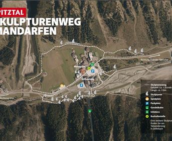
A number of different stone sculptures were erected around Mandarfen along the sculpture trail in celebration of the international stone sculpture artist symposium held in the inner Pitztal valley between July 2008,2010 and 2014. This was the start of an artistic campaign led by the respected artist, Kassian Erhart, which is set to continue over the next few years.

ZirbenPark circular route

A nature experience for the whole family. Fun, games and facts around the stone pine, also affectionately known as the “Queen of the Alps” is a high-alpine tree. Embark on a journey in our new ZirbenPark at the intermediate station of Hochzeiger. Find out about all facets of this precious type of wood on this special circular walk. The new approx. one kilometre long ZirbenPark adventure trail starts at the intermediate station, continues towards  Zollberg leading through a Swiss pine forest, past the Tanzalm hut and then back to the intermediate station. ZirbenPark’s highlight is the cone-shaped ZirbenZapfen adventure tower: this 12 metres tall adventure tower features a viewing platform and a 16 metres long tube slide. You can easily and conveniently get to the new ZirbenPark by gondola lift. The Zeiger restaurant at the intermediate station invites for a comfortable stop.

Piller Moor nature trail

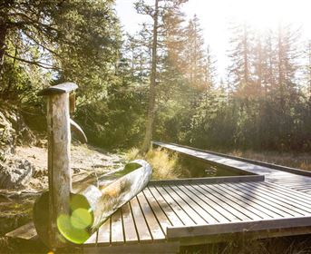
Located above Piller, on 1,535 m above sea level, the Piller Moor, regarded as one of Central Europe’s most beautiful alpine moors, stretches out over approximately 20 hectares. It was formed towards the end of the last ice age. Today, the Piller Moor is divided into two parts: the undestroyed Latschenhochmoor, a nature reserve since 1971, and the Putzenmoor located to the north-western side, where peat was already cut in the 19th century. Several information boards give background information regarding the formation as well as the commercial use of this alpine moor and about its interesting fauna and flora. Enjoy the panoramic view of this landscape from an 11 metres high watch tower.
Our tip: Piller Moor can also be experienced by wheelchair users and people with mobility problems: ca. 700 m of wooden planks were built environmentally friendly into the unmissable moor.

Wild animal adventure trail

On the trail of wild animals in Arzl-Wald, just by the “Waldeck” inn.
An instructive way to discover interesting facts about the region’s wildlife. This trail is particularly adventurous for children offering insights into the animal kingdom and takes approx. 1.5 hours with plenty of stops and opportunities to watch and be amazed.

Earth pillars circular route

The earth pillars in the Waldertal valley between Roppen and Arzl in Pitztal, are a little natural wonder. Only in very special climate conditions, these bizarre towers with capstones erode from moraines of former wide moraine fields. You can find these natural gems on the narrow road from Roppen on the south side of the river Inn, going over the hamlet of Waldele in the direction of the Walder stream. You may want to stop in one of the bends and walk just a few steps to the viewing platform and enjoy the grand panorama of the Inn gorge and the Walder stream gorge. From here, follow the road uphill to reach the Walder stream after the Hohenegg turnoff . Walk upstream to the waterfall and between the trees on the right, you can view the Walder earth pillars. On the steep slope on the Roppen side you can observe how earth pillars are being formed. If you continue walking to Hohenegg, you can discover further “capped” towers. The hike continues from Hohenegg over the Walder stream to the Wald sports grounds and then downhill passing the viewpoints and chapels back to the starting point. Alternatively you may start this hike from the large car park near the sports grounds in Wald or in combination with the suspension bridge over the Pitztal Ache or the Luis-Trenker trail, or else access via the new cycling path through the Roppen gorge.

Path of Pitztal’s legends "Pitztaler Sagensteig"

Find out about the myths and legends of Pitztal at five stops along this path up to the catered mountain hut Gletscherstube at the foot of the Mittelberg glacier.

Happy Track

Three interactive stations focusing on the subject of “self-esteem”. Old thought patterns are questioned, inner strengths are brought to the fore and affirmations are used to show ways in which to gain confidence. The Happy Track starts at the public car park next to the community hall in the centre of Wenns. 

Luis-Trenker nature trail 

This trail, named after the world famous mountaineer Luis Trenker whose roots go back to Arzl, leads underneath the suspension bridge through the Pitzenklamm gorge all the way to the Innschlucht gorge. The steep rock faces, lush flora and the glacier-fed Pitze river, cast a spell over visitors to this gorge. Information boards courtesy of the Kaunergrat Nature Park, provide the keen hiker with background information on plants and wildlife.

Sitebuilder 
sculpture trail
sculpture trail
ZirbenPark circular route
View of the Pillermoor in the Kaunergrat Nature Park
Wild animal experience path
Earth pyramids in the hamlet in Wald
Luis Trenker path
Luis Trenker path
Luis Trenker path at Pitzenklamm
track of senses
track of senses

Categories

Difficulty

Distance

Distance ranges from 0km to 7km

Duration

Duration ranges from 0h to 2h

Altitude

Altitude ranges from 20m to 370m

Walking to the Chapel of the White Light

Ausgangspunkt
Bergstation Gletscherexpress (2839m)
Endpunkt
Bergstation Gletscherexpress (2841m)

Piller Moor nature trail – wheelchair-accessible route

Ausgangspunkt
Car park at the entrance to Piller Moor (1526m)
Endpunkt
Car park at the entrance to Piller Moor (1526m)
It is approximately 500 metres on a gravel path to the turf house square [Torfhüttenplatz] where the path forks off. Turn left to get to Piller Moor natural landmark and the moor observation tower or turn right to walk past the winter feeding station and a path that leads to the peat cutting area. After approximately 200 metres you will reach a platform, which reveals a view of the “Putzenmoos” that is well worth seeing. Here, peat was still cut until the early 1970s. The wheel-chair accessible path then continues for approximately 300 metres until you reach the moor. From there, the road is no longer suitable for wheelchair users.  

Circular Route ZirbenPark

Ausgangspunkt
Mittelstation (2024m)
Endpunkt
Mittelstation (2024m)
The Swiss pine, also affectionately known as the “Queen of the Alps” is a high-alpine tree. Embark on a journey in our new ZirbenPark at the intermediate station of Hochzeiger. Find out about all facets of this precious type of wood on this special circular walk. The new approx. 1 km long ZirbenPark adventure trail starts at the intermediate station, continues towards  Zollberg leading through a Swiss pine forest, past the Tanzalm hut and then back to the intermediate station. ZirbenPark’s highlight is the cone-shaped ZirbenZapfen adventure tower: this 12 m tall adventure tower features a viewing platform and a 16 m long tube slide. You can easily and conveniently get to the new ZirbenPark by gondola lift. The Zeiger restaurant at the intermediate station invites for a comfortable stop.
 

Sculpture Trail

Ausgangspunkt
Mandarfen (1675m)
Endpunkt
Mandarfen (1677m)
„STONE SCULPTURE SYMPOSIUM“.
A number of diff erent stone sculptures were erected around Mandarfen in celebration of the international stone sculpture artist symposium held in the inner Pitztal valley between July 2008,2010 and 2014. This was the start of an artistic campaign led by the respected artist, Kassian Erhart, which is set to continue over the next few years.

Wanderung Wildtier Erlebnispfad

Ausgangspunkt
Parkplatz Galtwiesen (1177m)
Endpunkt
Parkplatz Galtwiesen (1177m)
After approximately 200 m from the Galtwiesen car park you reach the Jausenstation Waldeck, where the wild animal adventure trail commences. The trail shows interesting facts regarding the life of native wild animals. Do you know the tracks of the different animals? Do you know how far numerous animals can jump? You can discover and experience all this and much more at the different stations. This adventure trail is an adventurous hike into the animal kingdom, especially for children. You will need approximately 1.5 h including various stops at the stations, where you can take a look and be amazed. 

Experience hike Piller Moor

Ausgangspunkt
Car park at the entrance to Piller Moor (1525m)
Endpunkt
Car park at the entrance to Piller Moor (1528m)
The hike starts at Piller Moor car park/ bus stop. Along this circular route the origin of moors, moor flora and peat extraction is described. Enjoy a beautiful view of the Latschen High Moor from the moor viewing tower. This area in particular is of great fascination to visitors of the moor nature trail as it gives an insight in the slow evolution of these fascinating and increasingly rare habitats. Seven information boards explain the evolution of moors, the moor flora and peat extraction.

Pitztaler Sagensteig

Ausgangspunkt
Car park Mittelberg or bus stop Mittelberg Wendestelle (1733m)
Endpunkt
Car park Mittelberg or bus stop Mittelberg Wendestelle (1734m)
Follow the “Pitztaler Sagensteig” [path of Pitztal’s legends] with five stops - about the myths and legends of Pitztal - up to the catered mountain hut Gletscherstube at the foot of the Mittelberg glacier. You can return back to Mittelberg via the same path or follow the agricultural road or the Talwanderweg [valley hiking trail] to Mandarfen.

Happy Track

Ausgangspunkt
Mehrzwecksaal / Kirche (977m)
Endpunkt
Mehrzwecksaal / Kirche (991m)
The “Happy Track” starts at the public car park next to the community hall in the centre of Wenns. You will wak past historic buildings through Wenns for the first few metres to Hotel Pitztaler Hof. From there, head north and follow the signs to the “Talwanderweg”. Shortly after a small playground there is a junction, continue uphill in the direction of “Langenau”. The actual “Happy Track” starts there. There are three interactive stations focusing on the subject of “self-esteem”. Old thought patterns are questioned, inner strengths are brought to the fore and affirmations are used to show ways in which to gain confidence. At the end of the “Happy Track” there is visitor’s or “pathways book” which gives inspiration for the following day and you can also leave messages for others. Once you arrive at the small chapel in Steinhof, follow the signs again in the direction of the “Talwanderweg” to Wenns. The entire loop is almost six kilometers long and is manageable with an all-terrain pushchair.

Chapel path Arzl im Pitztal

Ausgangspunkt
Pfarrkirche Arzl im Pitztal (851m)
Endpunkt
Parkplatz Steige in Arzl im Pitztal (935m)
The starting point of the Chapel Trail is the Steige car park. From here, the trail leads past the Zangerl family farm shop in the direction of the village centre with the first stop at Arzl parish church. The church, first documented in 1358, is dedicated to Bishops Ingenuin and Albuin. On the cemetery right next to the church is the Our Lady, Help of Christians funerary chapel, a pilgrimage chapel from the late Gothic period. A steep path right next to the church continues to Lourdes Chapel, built in 1897. Hike back to the church via the same trail and then continue in the direction of Burgstall via a sunny uphill climb leading through forests and meadows and boasting wonderful views of the valley. Following the signs (“Kapellenweg Arzl”) you will reach the hamlet of Arzlair with the pilgrimage Chapel of Our Lady, majestically nestled on a hill like a castle. From there, continue downhill to Timls to the Chapel of Our Lady with ceiling frescoes by the Imst Rococo painter Josef Wörle. Now keep to the right, follow the signs, and stay on the road to the Steinhof fork. In the hamlet of Steinhof is the Chapel of the Holy Family, which was built in the mid-18th century, the last stop on the Chapel Trail. Walk along the valley hiking trail to the bus stop at the junction to Timls. Here you can conveniently get on the public bus to Arzl and get off at the town hall [Gemeindeamt]. If you prefer to hike back to Arzl along the valley hiking trail, please calculate another 30 minutes for the two kilometres back to the starting point (Steige car park).
Information

Webcams

Information

Weather

Information

40 - 325cm

Information

18 open lifts

Information

41 open slopes

Öffungszeiten

Now open

Angebot suchen

Search for offers